Ok so how do you get the best out of a limited 2 weeks annual leave (16 days) trekking holiday in the Canadian Rockies?
 |
| Mount Rundle |
 |
| Takakkaw Falls |
Well if you don't have friends over there to steer you in the right direction or have never been there before, you basically have two options, either sort it yourself (as i would normally do) or make use of a reputable trekking company. The likes of Edward Whymper would happily 'engage the services of a local guide' so was Whymper a tourist or an explorer?
Planning the visit yourself can be as much a part of the holiday as the actual trip, and it does engage the 'pioneer spirit' but, however well you pre plan it, your still probably going to loose some precious time getting things wrong. Of course these 'lost days' can on reflection be the most memorable, but its all about finding the right balance.
 |
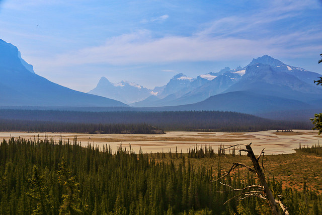
| Saskatchewan River Crossing |
 |
| Five lakes hike - Jasper |
For this trip we chose HF Holidays https://www.hfholidays.co.uk I think I can guarantee in the two weeks, we met more of the local community, and were shown more of the unfrequented best bits of the Rockies than we could have possibly managed by planning it ourselves.
With a small group the guides have the flexibility to re arrange treks on the spot due to adverse weather conditions or local environmental conditions i.e. Bear and Wolf issues. Quite often decisions and options have to be made the day before or even on the day itself. During our trip we had to reschedule a number of days due to forest fires in British Columbia, and subsequent road closures.
Most of us have experienced the nightmare problems of parking in the Lake District during high season, the key benefit of an organised trekking holiday is having the transport provided.
 |
| Five lakes hike - Jasper |
Front Country & Back Country?
The explanation of either of theres terms is I think where the vastness of the Rockies comes into play and makes the experience somewhat different to that of hiking in the European Alps.
Most of the day trails in the Rockies are regarded as 'Front Country', due to the terrain a lot of these tend to be out and back along the same route. If you want to do a circuit then it usually means heading into 'Back Country' often requiring a permit for hiking over and into a different mountain range. Typically 'Back Country' trails can only be reached by foot or boat, and often require several hours of trekking, meaning you are some 10 miles plus or a days walk from the nearest road or developed area.
I guess you need to consider how much of the Rockies you want to see in your given time. Most of the well known adventure trekking companies offer linear routes through the Rockies with some limited Back Country camping. Remember the Canadian Rockies are vast, and each of the main National Parks, Yoho, Kootenay, Jasper & Banff, are distinctly different.
 |
| View from Whistlers Peak - Jasper |
A linear trek can be a great idea if you're staying for longer than 2 weeks. So consider the options of a multi centre visit first and then a linear route after, this will give you a more informed idea of your preferred linear trekking area. Conversely a linear trek first then a multi centre break, will allow you to wind down and recover in some of the very convivial Front Country accommodation, but you might find that you wished you had spent more time in just one of the National Parks.
 |
| The mightly Athabasca Falls |
Highlights
Almost too many to mention, you will get AVS (Awesome View Syndrome).
Banff - A great centre to start from, with some splendid coffee shops and pubs, a good few short riverside walks to Bow Falls & Cave & Basin National historic Site, just to break you in on the first day.
Icefield Parkway - Just for the drive...Bow Valley lake and the view from the Saskatchewan River Crossing
Yoho NP - The towering Takakkaw Falls, and the turquoise-coloured Emerald Lake trail.
Johnson Canyon - Hike up the canyon to the Inkpots, and meadows, a beautiful introduction to the Rockies.
Athabasca Falls & Glacier - Try and hire a local guide to walk on the glacier from the base
Jasper - Take the Sky Tram to Whistlers Peak and trek to Indian Peak, plus visit The Other Paw Bakery and Cafe. Stay at Becker's Chalets, If you can get in?
Kananaskis - Burstall Pass Trail, almost into Back Country
Do's & Don't
 |
| Bow River from BeckerS Chalets |
-Do set off very early as it gets busy and car parks fill up quickly.
-Do visit the Nat Parks website to check the latest trail conditions and restrictions. banff
-Do pack, and more importantly, learn how to use Bear Spray.
-Do read the Rules of the National Parks i.e. fires warning/cooking/camping restrictions.
-Do take a polarising or grad filter for your camera.
-If your there for the photography, do think about the time of day and the direction the sun will rise and fall, look at some of the best images you have seen of the Rockies and try and evaluate what time of day they were taken before you set off.
-Do pack a good hat and a spare.
Not many but
-Don't underestimate the distance to be travel.
-Don't go to Lake Louise mid afternoon.


 Recommend the Royal Oak pub in Cardington, circa 15th Century free house. Great for Sunday Lunch but check opening times for the rest of the week. You can extend this walk buy continuing up Caer Caradoc to the Three Fingers Rock at the southern end and the returning via the drovers road.
  Also an option to carry on to the Gaer Stone and return Willstone Hill via Battle Stones rocks. This is not marked as a green ROW but the path is obvious.


